RECENT BSM / BSGCC LOGOS
Have you, like me, sometimes wondered why the Burnt Store Marina monthly newsletter is called The Beacon, when there are no lighthouses anywhere near the marina? The community leaders may have also realized this when they recently changed the front gate and golf course signage logo from a lighthouse to a sailboat, a change which I, as a sailor, appreciated.
Would you therefore be surprised to learn that for many years, long before Burnt Store Marina was established, there was, in fact, a substantial lighthouse located just off of our shores?
Special thanks to Neil E. Hurley, Historian for the Florida Lighthouse Association, for information about this lighthouse. He wrote a comprehensive article about it in the March, 2007 issue of Lighthouse Digest. Much of the detail below has been sourced from that article, with permission. Also, thanks to John Valickas of the Placida / Cape Haze Memories Facebook page for profiling the lighthouse, and alerting me to Mr. Hurley’s article about it.
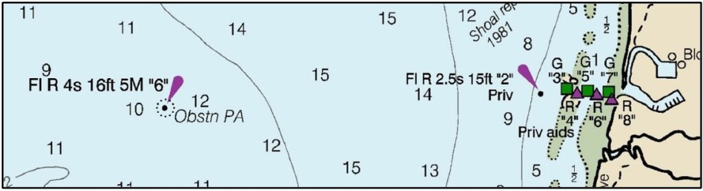
From 1890 to 1943, the Charlotte Harbor Lighthouse was located very close to where the current Charlotte Harbor navigational Marker 6 is positioned, and served much the same purpose. This conclusion is based upon the 1895 US coast survey reported position of the lighthouse, adjusted for datum changes, and compared to the Marker 6 location reported in current (2025) charting software.
WEST OF THE BURNT STORE MARINA HARBOR ENTRANCE
In October, 1888, Congress passed an appropriation for $35,000 for “a light or lights and other aids to guide into Charlotte Harbor, Florida.” From this appropriation, both the Gasparilla Island Lighthouse (now known as the Port Boca Grande Lighthouse, located at the southern tip of Gasparilla Island) and the Charlotte Harbor Lighthouse were built. The Charlotte Harbor Lighthouse was positioned eight and one-half miles east of the mouth of Boca Grande Pass. The lighthouse was designed to assist ships navigating to Punta Gorda, which in 1886, had become the southern terminus of the Florida Southern Railroad. The light marked the deep-water channel and the point where inbound boats made a 90 degree turn to port to head north toward Punta Gorda.
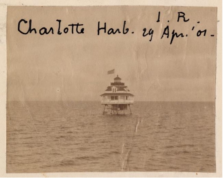
Mr. Hurley states in his article that “it stood on a cast-iron pile foundation that provided a landing area just a few feet above sea level. On top of the foundation, the wooden lighthouse was described as being a square white one-and-a-half story structure, with green blinds and a brown roof, surmounted by an iron lantern. The lantern was painted black. The light was 37 feet above mean sea level. A 16-foot-long boat was hung on davits for the use of the Keeper.” He goes on to say that “inside the dwelling, the first floor contained a bedroom and a kitchen/sitting room. The second story contained another bedroom and a work room. The work room also doubled as the watch room. Iron steps or a ladder led from the landing to the dwelling, while inside the dwelling the steps were wooden. Access to the lantern room was through a trap door in the floor.”
Mr. Hurley provides extensive details about the lighthouse keepers and the type of lights deployed during its history. The Charlotte Harbor Lighthouse was staffed from 1890 until 1912, but continued in automated operation until 1943.
The 1895 Coast Survey map (shown below) states that light No. 5 was a fixed red (F.R.) while current Marker 6 is a 4-second-interval-flashing red. A 1909 USCG Coast Survey report listed the DMS position of the lighthouse using the 1901 U.S. Standard datum as 26º 45’ 34.92” N; 82º 6’ 38.769” W, which, converted to NAD83 (1999) is 26º 45’ 35.917” N; 82º 6’ 38.10” W, very close to the same position of current Marker 6.
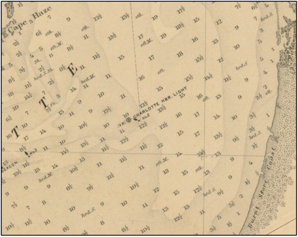
SURVEY CHART NO. 175 – SAN CARLOS BAY
TO LEMON BAY INCLUDING CHARLOTTE
HARBOR (CURRENT DAY BURNT STORE
MARINA WOULD BE DUE EAST OF THE LIGHT)
The main cargo for the ships using the harbor was phosphates from the deposits up the Peace River, as well as passengers and freight connecting with the railroad in Punta Gorda. Several factors contributed to the demise of this lighthouse. In 1896 Henry Plant, the new owner of the railroad that terminated in Punta Gorda (and owner of a competing line to Tampa), removed the rails to the deep water dock in Punta Gorda. This effectively cut off rail access for ocean going deep keel boats. In 1907 the Charlotte Harbor and Northern Railway was completed between Arcadia and Boca Grande, providing a new direct outlet to deep water for the phosphates being mined from the upper Peace River valley. By 1943 the channel to Punta Gorda had experienced further silting and the 53-year-old lighthouse had deteriorated to a dangerous condition. It was dismantled and replaced by a light on a ten-foot pole. The iron base was not removed until 1975.
Each time you cruise up or down Charlotte Harbor, or leave Burnt Store Marina and pass by Marker 6, take a moment to reflect on the legacy of this historic navigational Beacon.